

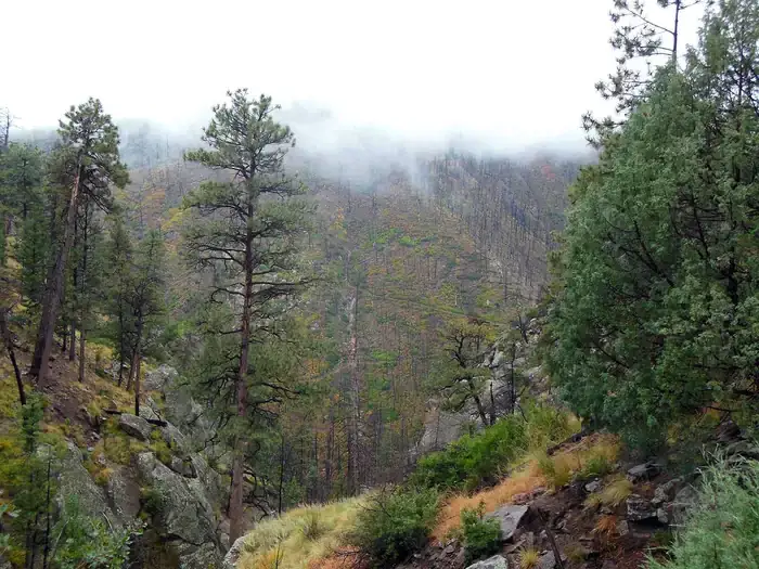


Ponderosa Group Campground — Bandelier National Monument
 Los alamos, NM

 Picnic Table
 Fires
Fires Vault Toilets
 Potable Water
 Pet Friendly

Check availability
The host has not added an availability calendar yet.
Amenities, activities and location
 Amenities
Activities
 Hiking
 Landscape
 Desert
 River
River
Getting there
15 Entrance Road, Los alamos, NM, 87544, US

Good to know
- Check-in
- 12:00am
- Check-out
- 12:00am
- Pets
- Allowed
- Campfires
- Allowed

About this campground
## Overview \*\*\*Ponderosa Group Campground will tentatively be closed starting October 8, 2025 while the park works to complete a major water line replacement/improvement project. The closure is anticipated to the entire month of October\*\*\*\_\_Ponderosa Group Campground is located 6 miles (9.7 km) from the park's main entrance and is an ideal place to stay for large groups visiting Bandelier National Monument.
Read moreRead less
The campground is adjacent to Ponderosa Trailhead providing access to more than 70 miles (113 km) of hiking trails and is just a short drive from the Visitor Center, the [Frijoles Canyon Shuttle System][1] (mid-May to mid-October), and the town of Los Alamos, Valles Caldera National Preserve, Manhattan Project National Historic Site, and the Santa Fe National Forest.\_\_Ponderosa Group Campground is open year-round (water is only available from mid-May to mid-October, subject to delays and/or early shut off). Same-day reservations are not permitted.\_Frijoles Canyon and the park Visitor Center are accessible only by shuttle bus from mid-May to mid-October. The shuttle bus system stops at the Bandelier Visitor Center, Juniper Campground, and the White Rock Visitor Center in the town of White Rock. Outside of the designated shuttle bus period, visitors may access all park areas by private vehicle.\_\_Public events are prohibited at Ponderosa Campground. Private events that adhere to campsite capacity limits, may be permitted after obtaining a special use permit. Visit the park's [Permits & Reservations][2] web page or call (505) 672-3861 ext. 1102. ## Recreation Accessible from Ponderosa Group Campground, the Ponderosa Trail descends into the park through ponderosa pine forest and connects to many [other trails][3] including the Middle Frijoles Trails which leads 8 miles (13 km) through Frijoles Canyon to the Visitor Center and [Main Loop Trail.][4] The Visitor Center houses museum exhibits, park film, information and ranger programs, Western National Parks Association sales outlet, and more. Entrance to Frijoles Canyon and the Visitor Center is by [shuttle bus][1] only from mid-May to mid-October. These areas are accesibile by private vehicle outside the shuttle bus period.Although rock climbing is prohibited within Bandelier National Monument, many popular climbs are within a short drive up Route 4 into the Jemez Mountains. ## Facilities This campground is located at 7600 feet (2316 m) and is usually free of snow from mid-April through mid October. Water is not available during any months with freezing temperatures (potentially mid-October to mid-May). Vault toilets (with no running water), drinking water, a picnic shelter, picnic tables, food storage lockers, and campfire rings are provided at this facility. No hookup campsites are available. These sites are tent-only, but one RV per site can be accommodated in the parking area. Each site can accommodate between 10 and 50 people. Check-in time for the campground is 4:00 pm. Check-out time for the campround is 11:30 a.m. Group Picnics: Sites can be reserved for large group picnics, however the fee and process is the same as reserving the site for an overnight stay. ## Natural Features Bandelier National Monument protects over 33,000 acres (13,355 ha) of rugged, beautiful canyon and mesa country which features evidence of human presence going back over 11,000 years. Petroglyphs, dwellings carved into the soft rock cliffs, and standing masonry walls pay tribute to the early days of a culture that still survives in the surrounding communities. Bandelier National Monument sits at the southern end of the Pajarito (Spanish for \"little bird\") Plateau. The plateau was formed by two eruptions 1.6 and 1.4 million years ago. Home to the Bandelier Wilderness, Bandelier ranges from 5340 feet (1628 m) at the Rio Grande River to the south and 10,199 feet (3109 m) at the summit of Cerro Grande to the north, almost a mile (1.6 km) of elevation change in just under 12 miles (19 km). This elevation gradient creates a unique diversity of habitats specific to Northern New Mexico. The diversity of habitats and quick access to water supported a relatively large population of Ancestral Pueblo people. Currently, Pi\_\_on-Juniper woodlands dominate in the southern parts of the park transitioning through ponderosa pine savannahs and forests, finally reaching mixed conifer forests at the highest elevation. Scattered throughout the park are desert grasslands, montane meadows, and riparian areas in the canyon bottoms. Over 70 miles (113 km) of trails at Bandelier climb in and out of deep canyons and cross large flat mesas, showcasing the entire spectrum of volcanic geology and ecosystems found within the park.The park is home to over 55 species of [mammals][5] including mule deer, Abert's squirrels, mountain lions, black bears, and 16 species of bats. [Reptiles][6] and [amphibians][7] of all shapes and sizes can be seen. [Birds][8] such as Steller's jays, canyon towhees and mountain chickadees stay year-round, whereas turkey vultures, western tanagers, and black-headed grosbeaks are summer residents. ## Nearby Attractions The town of Los Alamos has shopping, museums, amenities, a movie theater, ice rink, ski hill, and is home to the Los Alamos unit of [Manhattan Project National Historic Site.][9] Nearby Department of Energy and US Forest Service lands provide trails which accommodate pets. [Valles Caldera National Preserve][10] is 16 miles (26 km) west of Bandelier. [Jemez Historic Site][11] is 37 miles (60 km) west. [Pecos National Historical Park][12] is 70 miles (113 km) southeast. Santa Fe, 40 miles (64 km) south of the park, is home to the New Mexico state capitol, museums, historic districts, art galleries, food, accomodations, and more. [1]: https://www.nps.gov/band/planyourvisit/shuttle.htm [2]: https://www.nps.gov/band/planyourvisit/permitsandreserevations.htm [3]: https://www.nps.gov/band/planyourvisit/short-trails.htm [4]: https://www.nps.gov/band/planyourvisit/pueblo-loop-trail.htm [5]: https://www.nps.gov/band/learn/nature/mammals.htm [6]: https://www.nps.gov/band/learn/nature/reptiles.htm [7]: https://www.nps.gov/band/learn/nature/amphibians.htm [8]: https://www.nps.gov/band/learn/nature/birds.htm [9]: https://www.nps.gov/mapr/los-alamos.htm [10]: https://www.nps.gov/vall/index.htm [11]: https://nmhistoricsites.org/jemez [12]: https://www.nps.gov/peco/index.htm
From The Dyrt · checked 19 Jun 2026
Reviews
This campsite offers a stunning natural environment that many campers find transformative and soul-soothing. Reviewers highlight the beautiful open spaces filled with trees and wildflowers, as well as the peaceful atmosphere that allows for a true escape into nature. The proximity to a charming town with restaurants and shops adds to the overall experience, making it ideal for day trips. With no significant negative feedback noted, this site is highly recommended for those seeking a serene camping experience.

Where to book
Campertunity shows the listing information, then hands you to the campground’s available booking route.

Ponderosa Group Campground — Bandelier National Monument
Last checked Sep 2026 Book with the campground or listed provider
- Review final availability and terms before paying
- Your booking is completed on the selected service
How complete and verified is this campground?
Campgrounds add and verify details to help you know what to expect. The higher the level, the more verified information you get as a camper.
 BasicLevel 1Some basic info added0 – 20% completeCompleted
 DetailedLevel 2More details verified68% completeCurrent level
 PromotedLevel 3Most details verified80 – 100% complete
Ratings, availability, photos, and policies are more reliable as the level increases.

Questions & answers
Get quick answers, or reach out to the host.
Ask the host anything you need to know before booking.
Nearby campgrounds
Something doesn't fit or is wrong?
Tell us what has changed and we will pass it on to the campground.
 Suggest changes